


SAVE THE RAIL TRAIL GREENSPACE
NO Clement Extension!
Kelowna BC Canada
Welcome
The Rail Trail Greenspace Association is working to preserve the Kelowna BC Rail Trail Greenspace that runs alongside Mill Creek at the base of Dilworth Mountain.
The City wants to replace the Rail Trail with a road going from Spall to Hwy 33. We want to stop that.
What the City Plans To Do
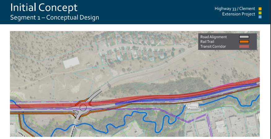
The City is planning a new 2 km road, called the "Clement Extension" or the "Highway 33 Multi-Modal Corridor," to connect Spall Road to Highway 33 (see map). The multi-use path would be moved to make way for the road, the wetlands would be buried and concrete retaining walls cut into Dilworth Mountain. Instead of the Rail Trail's tranquil natural surroundings, users would be separated from the new road by an artificial 'green strip'.
A
For a summary to July 2024 of the history of the Clement Extansion and the City's perspective click here
For the full 10 year Plan proposed by the City, please click here
Images of the plan for the new road.
-
(A) sketch showing the approximate route from Spall to Highway 33
-
(B) cross-section showing retaining wall, two lanes of traffic, green strip, rail trail, sidewalk
Note that the road is wider near the roundabouts (up to 5 lanes), then narrows down to 2 lanes between these intersections.

B
Why NOT build the Extension?
$210 Million for 2 km? No Real Solution and Full of Problems!
The City wants to spend $210 million plus — about 18% of Kelowna’s 10-year transportation budget — to build just 2 km of road. That’s more than twice the cost per kilometre of Kelowna’s other road projects. And it probably won’t fix traffic.
Think about it: if you’re driving from the bridge to Highway 33, you’d still have to turn left, cross downtown, and only then get on the new “bypass.” Enterprise Way already bypasses the highway — and it’s still jammed with traffic! Building more roads often just attracts more cars (called induced demand ) , so congestion usually comes back — sometimes worse. Cities like Toronto, Seoul, and Paris have even removed roads without seeing more traffic. If we’re going to spend $135 million, let’s spend it on things that actually make travel safer and easier — not just add more pavement.
This project also faces big construction challenges.
-
The route runs through a narrow corridor full of gas pipelines, power lines, and a substation — making it expensive and risky.
-
Engineers are planning 400 m of retaining walls, up to 16 m high.
-
The road would make the Rail Trail noisier and less safe, putting families and commuters just metres from car traffic.
-
The land has unstable soil, a high water table, and possible contamination from old industrial sites — all requiring costly cleanup.
And here’s the kicker: this road was supposed to connect to a second bridge and extend to UBCO — but neither of those projects is happening. Meanwhile, Highway 33 still has 4 of the 10 most dangerous intersections in the Interior. Imagine what $135 million could do if it was spent on: Safer crossings; synchronized lights; more buses and better transit; protected bike lanes and walking paths. These solutions would actually reduce congestion as Kelowna grows — without destroying nature.
Serious Environmental & Cultural Impacts :This Greenspace Is Irreplaceable
Urban greenspaces improve mental health, reduce flooding, and cool the city in summer. Once this green space is gone, it’s gone for good. Brandt’s Creek is already buried, and Mill Creek is now the only natural waterway left north of Harvey. Every day, 600–1,200 people bike, walk, or run on the Rail Trail. The Clement Extension would destroy wetlands, cut into the trail, and go against the City’s goals and promises to fight climate change, grow its urban tree canopy, and support walking and biking and active trasnportation. Kelowna has already lost almost 25% of its green space since 2001 — one of the worst losses in Canada. This area is home to fish, wildlife corridors, and species at risk. Building the road would require several environmental approvals, but the City has not shown the public any completed studies. There are also known First Nations heritage sites nearby. Other cities are spending money to “daylight” (unbury) their creeks. This project would do the opposite — bury more of our natural space. In a City survey, 44% of residents said they didn’t want this road at all — and those who supported it were told it would cost only $60 million. At $135 million and counting, public support would likely drop even more.
Is the Road a Done Deal? NO! A Smarter Future Is Possible
It’s not built yet. There’s no final design, no public environmental studies, and no confirmed permits. This project is still in the early stages. That means we have time to stop it.The Clement Extension is expensive, unnecessary, and harmful. We don’t need to sacrifice nature, heritage, and safety for a road that won’t even fix traffic. Instead, we can invest in better transit, safer streets, and greener solutions that will make Kelowna easier to get around for everyone.
People enjoy the Trail as it is - just look what they're saying about it!


Take Action
Celebrate the Rail Trail!
Our Partners
These organizations and businesses share our vision for a greener and more sustainable future for the City of Kelowna. We welcome additional partnerships.

Kelowna Tree Protectors

Kelowna Cycling Coalition

Okanagan Climate Hub


Kelowna Climate Coaltition

Get in Touch
Save the Rail Trail Green Space Assn.
Kelowna, British Columbia, Canada
President : Rebecca Tyson
Treasurer: Anthony Morham